REVIEW · HELICOPTER TOURS
Auckland: 36 min scenic helicopter flight – Coast to Coast
Book on GetYourGuide →Operated by INFLITE Mt Cook Ski Planes & Helicopters · Bookable on GetYourGuide
A city, a coast, and a volcano crater—fast. I like how you pack Auckland landmarks and the West Coast black-sand scenery into a 30-minute flight, with clear commentary from the pilot. One real consideration: flights are heavily weather dependent, so you’ll want a bit of schedule flexibility.
This is a small-group scenic hop with a limit of 7 participants, and the route is built for quick variety. You’ll lift off from Albany, swing past Kumeu and Huapai toward Bethells (Te Henga) Beach, then run back across the central city and out toward Devonport and Rangitoto.
In This Review
- Key points that make this Auckland helicopter flight worth your time
- Why this 30-minute Auckland helicopter loop hits the sweet spot
- Albany to Bethells (Te Henga) Beach: black sand and volcanic cliffs
- Over the Waitakere Ranges: bush, water reservoirs, and the feeling of wild New Zealand
- Back toward downtown: Sky Tower, Viaduct Harbour, and the harbour bridge moment
- Devonport, North Head, and the Rangitoto crater finish
- What you actually get in the cabin: aircraft types and group size
- Price and value: what $358 buys you in 30 minutes
- Safety, weather reality, and how to plan around it
- Who should book this helicopter flight (and who might skip it)
- Should you book this Auckland helicopter tour?
- FAQ
- How long is the helicopter flight?
- Where does this flight go from and what does it include?
- What’s included during the flight?
- How big is the group?
- Are there weight or item restrictions?
- What if the weather is bad?
Key points that make this Auckland helicopter flight worth your time
- West Coast-to-city route: black sand beaches, volcanic cliffs, then straight into Downtown Auckland views
- Waitakere Ranges from the air: bush-clad terrain plus hidden water reservoirs
- Real landmarks in one loop: Sky Tower, Viaduct Harbour, Harbour Bridge, and the Waitemata Harbour
- Devonport and North Head: shoreline views that feel a world away from the city streets
- Rangitoto crater: a volcanic feature you can actually recognize, even from the sky
Why this 30-minute Auckland helicopter loop hits the sweet spot
If you only have a short window in Auckland, this type of flight is the fast lane. You’re not choosing between the city and nature—you’re seeing both in one continuous arc. In about half an hour, the scenery flips from surf-pounded coastline to downtown icons, then ends with a volcanic highlight.
The other thing I appreciate is how the tour is organized around views you can’t get from the ground. Roads are great, but they don’t show the shape of coastlines, the spacing of harbours, or how the Waitakere Ranges rise up behind Auckland. From the air, those patterns become obvious in minutes.
The drawback is simple: you’re at the mercy of the weather. Scenic flights can’t always fly when clouds and visibility get tricky, so you’ll get the best experience if you can shift timing if needed.
You can also read our reviews of more tours and experiences in Auckland
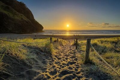
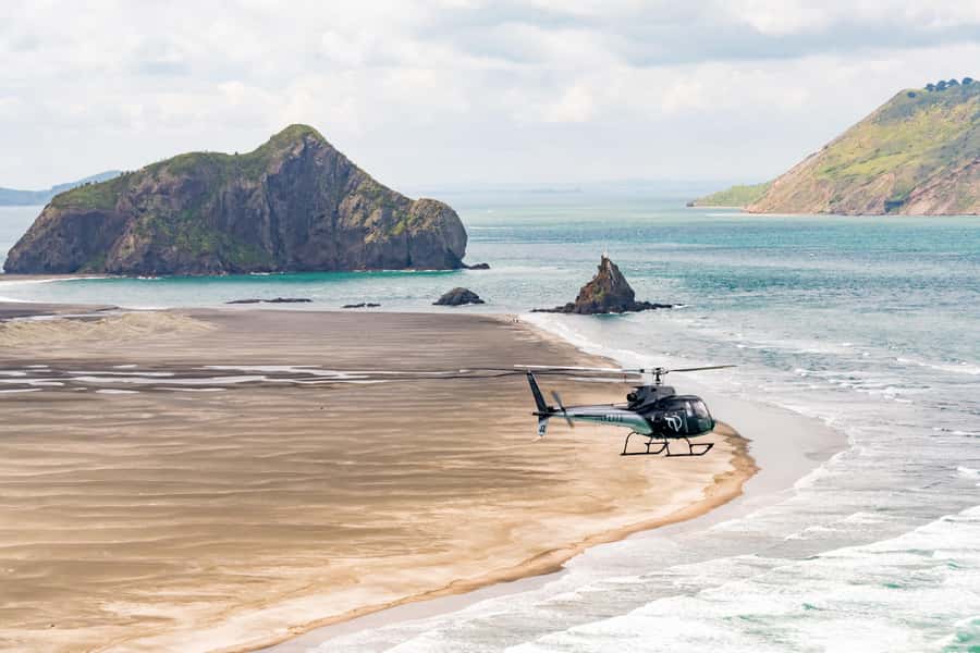
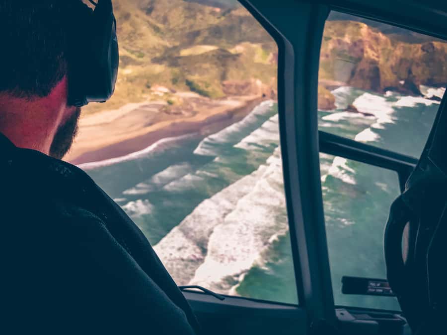
Albany to Bethells (Te Henga) Beach: black sand and volcanic cliffs
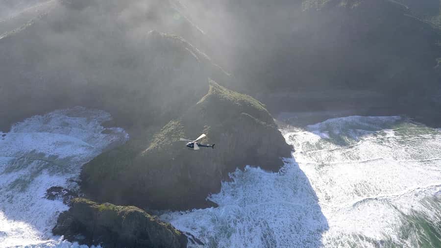
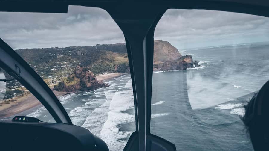
The flight starts by heading out from Albany, then moving over Kumeu and Huapai. That early segment matters because it sets up the big visual transition. You go from built-up areas into a coastline that feels rugged and raw.
Then you reach Bethells (Te Henga) Beach, where the tour turns south to follow the coast. This is where you’ll notice the defining Auckland West Coast traits: surf action, black sand beaches, volcanic cliffs, and jagged rocks and caves. From above, it’s easier to see how the shoreline breaks into coves and headlands instead of reading it as one long stretch.
One nice detail here is that the coastline isn’t just presented as a pretty view. It’s framed as a dramatic shoreline system—rocks, caves, and cliffs included—so you’re looking at geology, not just scenery.
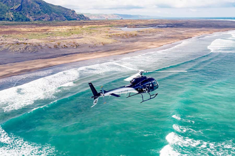
Over the Waitakere Ranges: bush, water reservoirs, and the feeling of wild New Zealand
After Bethells, the helicopter tracks over the Waitakere Ranges. This is a different mood from the beach segment. You’re trading wave noise for terrain—bush-clad slopes, a sense of scale, and a green wall rising behind Auckland.
What really makes this part stand out is that you also see water reservoirs hidden within the ranges. That small detail changes how you look at the landscape from above. Instead of thinking only about hiking trails or viewpoints, you get a quick glimpse of how the region is managed and supplied.
As you continue onward, the route also heads almost to the mouth of the Manukau Harbour. That’s another “you’re really going there” moment. From the air, it feels like you’ve left the city behind and entered a more elemental version of New Zealand—one where coastline, rivers of vegetation, and harbour edges shape everything.
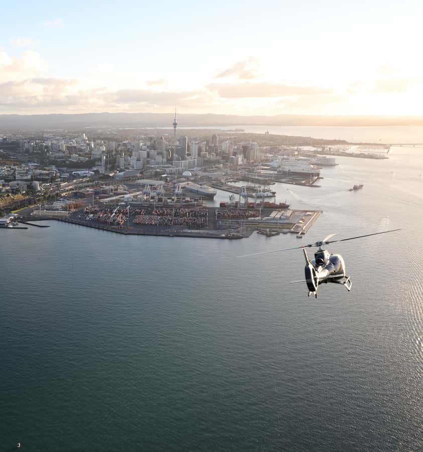
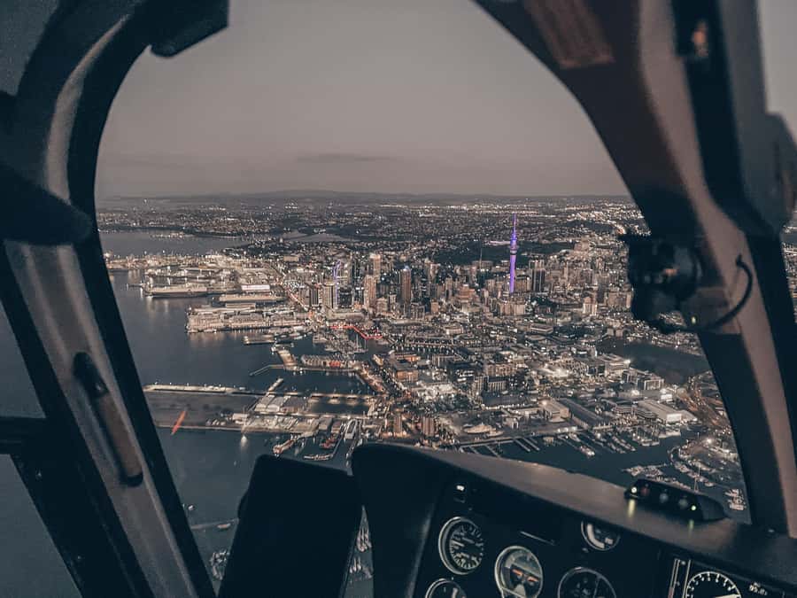
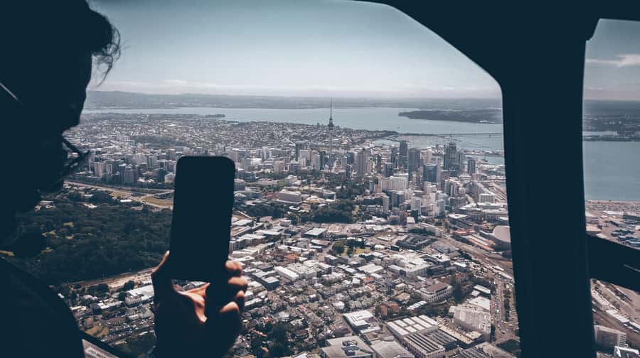
Back toward downtown: Sky Tower, Viaduct Harbour, and the harbour bridge moment
After the West Coast side, the flight swings back toward the central city area. This is when the tour becomes a headline reel of Auckland landmarks.
You’ll fly over Downtown Auckland and the Viaduct Harbour. Then you pass the Sky Tower and Harbour Bridge, which are the kind of landmarks that suddenly look like symbols rather than points on a map. When you see them from above together with the shape of the water around them, the city’s layout clicks.
A quick note on why this works: Auckland’s identity is tied to its harbours, and from street level you can miss that the harbours are doing most of the heavy lifting. The flight gives you that context in one pass, especially as you track across the Waitemata Harbour toward the north shore.
If you love getting oriented fast in a new city, this portion is especially useful. It gives you a mental map you can carry into the rest of your trip.
Devonport, North Head, and the Rangitoto crater finish
The route continues across the Waitemata Harbour to the Devonport Naval Base and North Head. These aren’t random stops—they anchor the “north shore” feeling, where harbour, landform, and maritime presence are part of the view.
North Head especially helps you understand the geography. You see how the land juts into the harbour, how the shoreline curves, and how the water wraps around the city edge. It’s the kind of perspective that makes you look back at Auckland as a coastal system, not just a metro area.
Then comes Rangitoto Island. You’ll view the crater of Rangitoto before returning to the heliport. Even if you’re not a geology nerd, a volcanic crater reads instantly from the air. It turns the flight from a scenic loop into a story about volcanic Auckland—city, harbour, and volcano in one compact journey.


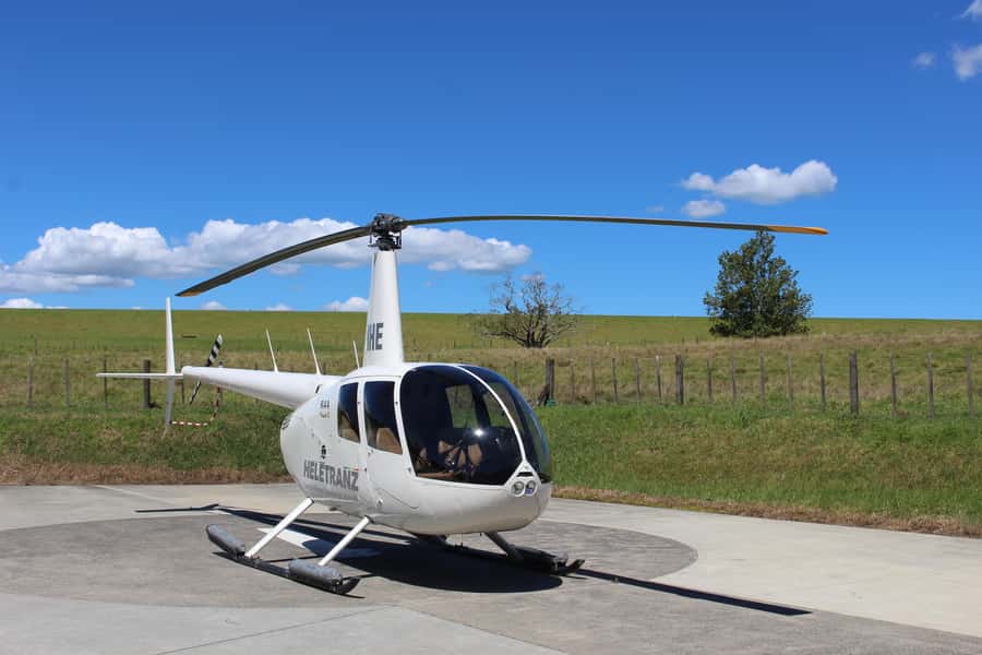
What you actually get in the cabin: aircraft types and group size
The tour is limited to a small group of up to 7 participants. That matters more than you might think with helicopters, because it keeps the experience feeling personal. You’re not fighting crowds for a view; you’re sharing a tight cabin and focusing on what the pilot is pointing out.
Aircraft can vary based on the number of passengers. For smaller groups, it may use a Robinson R444-7. For 2–3 passengers, you might fly on a Robinson R444-7, and larger groups can use turbine helicopters such as the AS350/355 Squirrel, Airbus EC130, Bell 427, or AW109s. The exact model depends on availability.
This is also why weight limits matter. People over 264 lbs (120 kg) aren’t suitable, and weight limitations apply on all flights. Plan your booking around that if you’re traveling with anyone close to the cutoff.
Price and value: what $358 buys you in 30 minutes
At $358 per person for a 30-minute scenic flight, this isn’t a budget activity. Helicopter tours are priced for convenience, aircraft use, and the kind of access you can’t replicate with driving.
So the value question becomes: does the route cover enough “wow” to justify the cost? In this case, it does, because the flight doesn’t only show one type of view. You get:
- rugged West Coast coastline, black sand beaches, and volcanic cliffs
- bush and reservoirs over the Waitakere Ranges
- a city loop over Downtown Auckland, Viaduct Harbour, Sky Tower, and Harbour Bridge
- a north shore run to Devonport and North Head
- Rangitoto’s crater
It’s also a time-saver. If you’re trying to see Auckland’s signature regions without spending hours on the road, this turns a big planning headache into a single, controlled window.
If you’re celebrating something—birthday, anniversary, or even a proposal vibe—this also has a practical advantage. You’re in the air together with a structured route and pilot commentary, and the experience is concentrated enough to feel special without turning into a whole day.
Safety, weather reality, and how to plan around it
Safety is built into the operation, and what I’d take from the experience feedback is that people feel confident with professional pilots. Still, the helicopter part is inherently weather-sensitive.
This tour is “scenic,” so it’s subject to visibility and flying conditions. Flights are heavily weather dependent, and dates and times are subject to availability. If your schedule is locked in tight, this is the one factor that can make or break your plan.
The good news is that you can treat booking as flexible because there is free cancellation up to 24 hours in advance for a full refund, plus a reserve now & pay later option. That means you can hold a spot and adjust if the day’s conditions don’t look good.
Also keep in mind rules inside the experience: no smoking, no vaping, and no intoxication. Drones are not allowed, and oversize luggage isn’t permitted. If you’re coming straight from the airport, travel light so you’re not stuck with anything that doesn’t fit the limits.
Who should book this helicopter flight (and who might skip it)
I think this tour is a strong fit for three types of travelers.
First, it’s great if you want a rapid orientation to Auckland. You’ll see how the harbours shape the city, and you’ll come away with a clearer mental map of where things are.
Second, it works for nature-and-city travelers who don’t want to choose. You get rugged West Coast scenes and then you’re over the city’s best-known landmarks in the same flight.
Third, it’s ideal for a milestone moment because the route is built for memorable views. The flight loop gives you multiple visual “chapters,” not just one long view.
It might be less ideal if you have no flexibility at all due to weather, or if you’re sensitive to the idea of weight restrictions. And if you hate rules around what you can bring into a small cabin, you’ll want to plan accordingly.
Should you book this Auckland helicopter tour?
I’d book it if you want the best odds of seeing a lot of Auckland in a short time, and you can handle the weather element. The route is thoughtfully balanced: West Coast drama, Waitakere terrain, city icons, and Rangitoto’s crater all in one 30-minute loop.
If you’re already the type who likes to plan days around views, this is the kind of activity that actually saves you effort. You’re not spending the day commuting between far-flung spots—you’re getting the big-picture geography from above.
If your schedule is rigid and you can’t risk a timing change, consider booking with a backup option. Weather dependence is the one tradeoff here, and it’s worth treating seriously.
FAQ
How long is the helicopter flight?
The scenic flight duration is 30 minutes.
Where does this flight go from and what does it include?
It flies from the Auckland area starting near Albany, passes over Kumeu and Huapai, continues to Bethells (Te Henga) Beach along the coast, crosses the Waitakere Ranges and toward the Manukau Harbour area, then returns over the central city including Downtown Auckland, Viaduct Harbour, Sky Tower and Harbour Bridge, and continues to the Devonport Naval Base, North Head, and Rangitoto Island’s crater before returning.
What’s included during the flight?
You get the scenic helicopter flight over Auckland’s West Coast, views of Auckland City and the Waitakere Ranges, iconic landmarks like Sky Tower and Viaduct Harbour, and detailed commentary from your pilot.
How big is the group?
It’s limited to a small group of up to 7 participants.
Are there weight or item restrictions?
Yes. People over 264 lbs (120 kg) are not suitable, and weight limitations apply on all flights. Oversize luggage isn’t allowed, and there are also rules against smoking, vaping, drones, intoxication, and other prohibited items.
What if the weather is bad?
Flights are heavily weather dependent, and date/time availability can change. If conditions don’t work for a scenic flight, you may need to adjust. You can cancel up to 24 hours in advance for a full refund.